Monday, October 31, 2022

Perfect Wichita Bluff Nature Area Conditions With Washington License Plates


With weather conditions near perfect, on this last day of the 2022 version of October, also known as Halloween, I took myself to the west entry to the Wichita Bluff Nature Area for some salubrious acquisition of endorphins via fast paced hill hiking.

As you can see, there is a little cloud action, rendering it not a totally clear blue-sky day.


That covered picnic pavilion you see here is my turn around point when I hike the Bluffs from the west.

This is also the high point of the Wichita Bluff Nature Area.

Heading home, after the Bluff hiking, I saw something I have rarely seen in Texas, that I used to see all the time when I lived in Washington.


A car with a Washington state license plate.

I do not know why zooming in on the license plate caused the water drops effect. I suspect my windshield is in need of being washed.

Washington has not changed its license plate design since the celebration of the centennial of Washington becoming a state in 1889.

That mountain you can almost see on the license plate is Washington's biggest volcano, Mount Rainier.

The current primary Texas license plate is plain black and white. And has changed several times since I've been in Texas.

I don't know why Texas does not have a license plate with the biggest volcano in Texas on it...

Sunday, October 30, 2022

Final Sunny Sunday October Lucy Park Visit


On this final sunny Sunday of the 2022 version of October, my motorized means of motion took me back to Lucy Park for some salubrious nature communing.

As you can see via the photo documentation, the recent rain has raised the water level of the Wichita River, but not high enough to reach the deck of the Lucy Park suspension bridge, which is something I have eye witnessed happening.

You can also see via the photo documentation that the leaves in the trees are finally beginning to get their proper fall color scheme.

In a couple hours I get to watch the Seattle Seahawks in my time zone for the first time this football season...

Saturday, October 29, 2022

Another Tale Of Two Cities


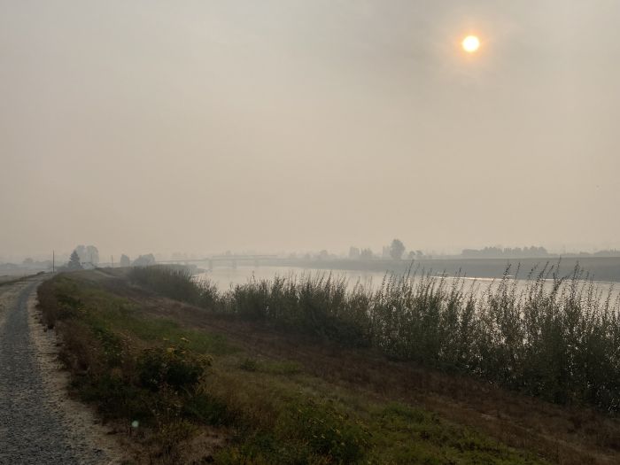
No, that is not the stunning skyline of beautiful downtown Fort Worth you are looking at here, or a completed section of Fort Worth's imaginary waterfront on its imaginary lake or imaginary island.

Speaking of Fort Worth, last week Elsie Hotpepper Took Us Back To America's Biggest Boondoggle where we learned that the pseudo public works project known as the Trinity River Central City Uptown Panther Island Vision, a vision Fort Worth has been trying to see for this entire century, now estimates it will take another decade to manage to dig a cement lined ditch, to add Trinity River water to, flowing under three little bridges, which took seven years to build, over dry land.

Seven years to build three little bridges. Over dry land.

About the same time Fort Worth began trying to build those three little bridges, another American town, Seattle, being boring a tunnel under its downtown, so that the earthquake damaged Alaskan Way Viaduct, which had long been a blight on Seattle's waterfront, could be removed.

That tunnel has been completed for three years. The Alaskan Way Viaduct is long gone. And the re-build of the Seattle waterfront is well underway, to be competed in 2025.

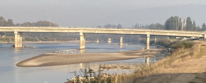
That photo at the top is from an article in today's Seattle Times titled Seattle Aquarium’s Ocean Pavilion will transform its focus and the waterfront.  

That photo is the first good look I have had of what a section of the Seattle waterfront looks like without the Alaskan Way Viaduct.

How is it one town in America can get big things done, whilst another town in America gets little done, in slow motion?

An excerpt from today's Seattle Times article shows a stark contrast between this ongoing project in Seattle, and what you might read in Fort Worth print media about its decades long project and its slow fruition...

YOU HAVE TO squint and use your imagination to visualize the finished product, but a transformation is underway on Seattle’s central waterfront. Where the Alaskan Way Viaduct once loomed, a walkway connecting Pike Place Market to Puget Sound is taking shape. The outlines of parks, playgrounds, bike lanes and a broad pedestrian promenade are beginning to emerge. One pier already has been rebuilt to welcome the public, and another is in the works.

Civic leaders say Seattle hasn’t experienced such a profound makeover since 1962, when the World’s Fair reshaped public infrastructure and propelled the city into the future. When the work is completed in 2025, foot traffic along Elliott Bay is expected to triple.

“This landscape that was dominated by a big, honking, gray, rumbling freeway will now be a massive public park for the people,” says Seattle City Councilmember Andrew Lewis, whose district includes the waterfront.

At the center of it all will be the Seattle Aquarium’s new Ocean Pavilion: a 50,000-square-foot exhibit space featuring sharks, rays and other animals and ecosystems from the tropical Pacific. Integrated with the city’s elevated walkway, the structure’s roof will be a public plaza with unimpeded views of the sunset and Mount Rainier. At ground level, a circular port called an oculus will allow passersby to peer into a 325,000-gallon coral canyon teeming with thousands of fish and invertebrates.

Projected to be done in mid-2024, the expansion is Seattle Aquarium’s most ambitious and costly undertaking since it opened 45 years ago in a wooden building at Pier 59. It’s a natural fit to anchor the waterfront redevelopment, Lewis says. The aquarium is already hugely popular, he points out, and the new building will enhance its ability to attract and educate new generations of visitors.

You reading this in the DFW zone, can you imagine reading an article in the Fort Worth Star-Telegram about such a project underway in Fort Worth? 

No. A town that takes seven years to build three little bridges over dry land, has some serious issues in dire need of being addressed...

Friday, October 28, 2022

Friday Rain Floods My Location Along With A Lot Of Thunder


Rain arrived, as per prediction, last night, along with the also predicted thunderstorming. Several hours into daylight the rain continues to rain down upon us.

Rain down upon us in amounts so copious that my primary exit route to my vehicle is flooded, which is what you are looking at in the photo documentation, looking down from my elevated patio vantage point.

I think this is the highest I have seen my exit route flood since I have been being flooded at my current location.

It may be possible to get to my vehicle, dry, via another route. 

I think I will just be content to stay indoors until the rain abates...

Thursday, October 27, 2022

Google Remembers Driving Miss Daisy To Monument Valley & State Fair Of Texas & More


Two days in a row, for the first time, Google has sent to my email, emails purporting to be memories from that day, in which I actually remember all the memories. 

At the upper left, that is me looking at my antique, long gone Casion digital camera, which had a feature which allowed you to rotate the camera lens towards oneself making for what, in this century, is known as a selfie.

In this particular 'selfie' we ae in Monument Valley, in Arizona, two days after getting off a Lake Powell houseboat. The day we exited the houseboat we stayed at the San Juan Inn, in Mexican Hat, Utah.

Below the selfie, on the lower left, that is the sky ride at the State Fair of Texas, in Dallas. 

The upper right is the lake in Veterans Oasis Park in Chandler, Arizona. Below the lake photo is Driving Miss Daisy Around Chandler Veterans Oasis With Snakes

The lower right is an arch in Arches National Park in Utah.

And now, on to today's Google memories...


The upper left is, once again, the State Fair of Texas.

The other four Google memories are all from Dreamy Draw Park at Piestewa Peak, in Phoenix. At that location we did Dreamy Draw Hiking Miss Daisy In & Out Up Piestewa Peak.

That was a memorable day. Mom had a lot of fun getting rolled on trails through the park. I remember at one point mom memorably saying, "I didn't think I'd ever get to do something like this again.

I do not think mom realized how steep the trail was, a couple times. The transit chair had good brakes.

So, there you go, my Google memories from the past two days...

Wednesday, October 26, 2022

The Dreaded Holiday Season Has Begun At Midwestern State University


A few days ago I saw that the annual installation of the Burns Fantasy of Light had begun at Midwestern State University. 

For me, this signals the start of the dreaded holiday season. 

We are now on the fast track to Halloween, Thanksgiving, Christmas and a Happy New Year.

I stopped at the Fantasy of Lights on my way back from Lucy Park today, to photo document Cinderella's carriage.

The evil step-sisters have not yet arrived.

Nor have Dorothy, Toto, the Tin Man, Cowardly Lion and the Scarecrow.

Tuesday, October 25, 2022

High Tide At Sikes Lake With Happy Geese


The sky has returned to being totally blue at my North Texas location, after being gray most of yesterday. 

The incoming rain dropped enough wet stuff to have water spilling over the spillway of the Sikes Lake dam. 

That incoming rain came in with a cold front with chilled in the 40s, last night, was warmed to only 58 degrees when I drove to Sikes Lake this morning.

It did not seem like enough rain rained down to fill Sike Lake back to full pool. But, apparently it did drip enough.


The former low tide tideflats are now back covered by a high tide. The geese seemed to be enjoying floating again, without their goose feet scraping the lake bottom.

I Googled "goose feet" to see what goose feet are actually called, and learned the proper term is pes anserinus.

Yes, I can see how pes anserinus would easily be the common term one would use when referring to goose feet.

Even colder temperatures are on the menu later in the week. Into the 30s. I need to go on my annual long underwear hunt...

Monday, October 24, 2022

Monday Morning Rainy Day In North Texas


It is a dark and stormy Monday morning at my North Texas location.

So far no thunderbooming, but strong wind gusts are blowing rain sideways.

In the view above we are looking west out of one of my living room windows.

The rain has already flooded my primary access route to the carport.

I need to make my way to the carport this morning to drive to the library to replenish my book supply.

This is the first heavy rain in many months. I don't know if one rainstorm can end a drought, but it seems it should put a dent in it...

Sunday, October 23, 2022

Strong Wind Grounds Sikes Lake Geese Population


On this next to last Sunday of the 2022 version of October, a cold front is moving into town, with wind gusting around 45 mph.

The temperature drop is scheduled to arrive later today, along with some rain and thunderstorming.

So, it was to Sikes Like I took myself for some high speeding leaning into the gusting wind. 

The Sikes Lake geese appear to be a bit traumatized, and grounded, by the strong wind. In the photo documentation it appears the geese are having a meeting, trying to decide what to do about the shrinking lake, pondering if maybe they should fly to some new roosting grounds, once the wind dies down.

I can not remember when we last had a strong thunderstorm at my location. In previous years such happened frequently. 

The cold has not yet arrived. It is 84 in the outer world, right now, coming up on 2 in the afternoon...

Saturday, October 22, 2022

Elsie Hotpepper Takes Us Back To America's Biggest Boondoggle


Yesterday, Elsie Hotpepper tagged me in a Facebook post, which is what you see a screen shot of.

For decades now, Elsie and I have been blogging about the Trinity River Central City Uptown Panther Island District Vision.

More commonly known as America's Biggest Boondoggle.

The project to create an imaginary island has been going on for most of this century. I recollect the first time I found myself befuddled and appalled by this was a long ago Sunday edition of the Fort Worth Star-Telegram, with a HUGE banner headline touting "TRINITY UPTOWN TO TURN FORT WORTH INTO VANCOUVER OF THE SOUTH."    

What fresh ridiculous nonsense is this, I read and wondered? Who could have imagined the ridiculous nonsense could go on for so long, for decades, with little to show for the effort.

Well, there are those three little bridges, built over dry land, to connect the Fort Worth mainland to that imaginary island. Those three little bridges are waiting for a cement lined ditch to be installed under them, with Trinity River water diverted into the ditch, making the imaginary island.

The article Elsie Hotpepper directed me to was in the Fort Worth Report, titled 
City of Fort Worth prepares to kickstart Panther Island development — again.

Just the title to this article struck me as odd. The city is preparing to kickstart America's Biggest Boondoggle again?

I was not aware the development had stalled. The last it was much in the news was when Congresswoman's Kay Granger's son, J.D., was removed from the executive director job he was totally not qualified to do, whilst being grossly overpaid, and then hired by the Boondoggle, post firing, to be a Trinity River Vision Boondoggle consultant for $12K a month.

The only other news about the Boondoggle that I can recollect in recent years is those three pitiful little bridges finally being completed, after seven years, that, and Fort Worth got $400 million from the Democrat's infrastructure bill, which J.D.'s mother voted against.

It has long bugged me that, if, as touted, this is a vitally needed flood control and economic project, why has it limped along in slow motion, begging for a federal funding, rather than voting to pay for the vitally needed project themselves, like town's wearing their big city pants do?

And, need we repeat, this vitally needed flood control project is in an area which has not flooded in well over half a century, due to flood control levees already in place, which you in the more prosperous parts of America, already paid for. While other areas of Fort Worth, as in East Fort Worth, and other areas of Tarrant County, have real, serious, un-addressed deadly flood control issues.

Now, let's take a look at some of the gems of nonsense from this article about America's Biggest Boondoggle...

The Central City Flood Project could transform a partially blighted expanse of land just north of downtown into about 440 acres of prime real estate — also known as the Panther Island Project. 

Could transform a blighted expanse of land? Could? After all this time, all this money, this project is stuck at could? And it is now known, simply, as the Panther Island Project? When did that happen? Whatever happened to the Trinity River Vision Authority, over which J.D. Granger was the Executive Director for years.

No mention is made in this article of the Trinity River Vision Authority.

Or J.D. Granger.

Or that J.D.'s mother voted against the funding that might finally give Fort Worth enough money to dig that cement lined ditch under those three bridges.

The project, which has experienced decades of delays, received over $400 million in federal funding this year, enough money to design and build two bypass channels. The corps recently projected the project will take eight to 10 years to complete.

Is there no investigative journalist in the Fort Worth vicinity who might want to look into why and how this project has experienced decades of delays? We are up to two bypass channels now? Taking another decade to complete? Yes, this seems very vitally needed.

And the nonsense continues...

The new strategic plan will be the second iteration of a plan for the Panther Island Project. The city and Tarrant Regional Water District initially developed its plan for the island, also known as the form-based code, in the early 2000s and revisited it in 2016 — all before the project received over $400 million from the federal government.

New strategic plan? Does anyone know what the old strategic plan was? The city and TRWD initially developed its plan for the island, known as form-based code? So, the new total name of America's Biggest Boondoggle is Trinity River Central City Uptown Panther Island District Form-Based Code Vision?

And then we have this doozy, including a Fort Worth staple...

A redevelopment project the size of Panther Island in the core of the city is unique, said Kenneth Barr, chair of the Real Estate Council. “Other cities would be very envious of us having the opportunity,” Barr said. 

Oh yes, many towns in America would be envious to have an industrial wasteland adjacent to their downtown. And another one east of their downtown. Most big cities do not develop with such tracts of wasteland adjacent to their downtowns. Hardly anything to be envious of.

And, finally...

“My vision for Panther Island is that it’d be a world-class place for tourists to come and visit and see the best of Fort Worth, but also a place where our local residents can enjoy and feel like it’s for them as well,” Landeros said. 

How can anyone who has been to an actual world-class tourist destination possibly think this imaginary island can ever possibly be such? Just look at that stunning skyline of beautiful downtown Fort Worth you see in the screen cap at the top. This is not a world-class town in any sense of the term....

Friday, October 21, 2022

Holy Smokes From Nephew Jason In The Skagit Valley


Incoming smoky email from my Favorite Nephew Jason. No text. Just three smoky photos, and an email subject line of "Holy Smokes".

That is the I-5 bridge across the Skagit River you see above. It does not look too smoky.


Another look at the Skagit River, and the bridge across the river connecting Burlington and Mount Vernon. This view is looking east. Under normal clear sky conditions you would be seeing the foothills of the Cascades.

I just realized, from this view, with no smoke, you would also see Hoag Hill, which is in Mount Vernon, a short distance from the bridge.


I can not tell where we are in the above photo, but with the smoky sun in about the same location as the previous photo I assume we are the same location. But, where did the bridge go?

Today we are having a red flag warning day at my current Texas location.

A red flag warning is a wildfire danger warning. High winds today, along with dry conditions and temperatures into the 90s, are what makes for a red flag warning.

Thursday, October 20, 2022

Washington Air Quality Worst In The World


The past several days I have been hearing from multiple people in the Pacific Northwest zone reporting that the smoke from multiple wildfires is the likes of which no one has previously experienced in the lowlands of Western Washington.

The above screen cap is from an email from my Favorite Nephew Jason, subject line: "Struggling for fresh air in the PNW" with email's text saying...

"DO NOT travel to Birch Bay today.  Whatcom County has the worst air quality on the entire planet right now.  We are being advised to stay indoors today.   I have already sneezed many times this morning".

I had not planned on traveling to Birch Bay today. 

And then, yesterday, Linda Lou sent this to my phone...


With text saying, "On the Francis Road headed toward Mount Vernon: a view of our smoked filled valley. It is very bad".

And then we have this screen cap from today's online version of the Seattle Times.


One of the links goes to an article titled "Seattle air quality among worst in world."

In all my years living in Western Washington I recollect many wildfires in the Cascades. I do not remember those wildfires ever resulting in thick smoke reaching the flatlands of the Puget Sound zone.

Wednesday, October 19, 2022

Overheating On Cool Walk Around Sikes Lake With Missing Horse


This morning, upon waking, the thermostat was indicating the interior temperature was 63 degrees. I lasted about an hour before switching the climate control system from cool to HEAT.

A few hours later the outer world was heated to almost 60 degrees when I drove to Sikes Lake for a long walk with the geese.

Soon upon walking I discovered I was overdressed, top-wise, with the hooded sweatshirt being one layer too many.

A couple years ago I made mention of the fact that one of the Wichita Falls Art Museum's outdoor sculptures had been horsenapped. 

The plaque, at the side of the paved trail, installed shortly before the horsenapping, still makes mention of the missing horse with the words "Apple-oosa (large horse)".

No clue why the large horse was called Apple-oosa. The large horse had works of multiple famous artists on its coat of many colors. Such as Picasso, Rembrandt, Matisse, Van Gogh and many more.

I suspect the mystery of the horsenapped horse will never be solved...

Tuesday, October 18, 2022

Remembering The Civil War & When Linda Lou Pointed The Way Up South Mountain In Phoenix


 Today is one of the rare times that I remember the memories Google emails me, every day.

The upper left is a Civil War battle reenactment I watched at a battlefield west of Weatherford, or maybe it was the battle I watched southwest of Granbury. What I know for sure is I watched a Civil War battle reenactment on two occasions, one near Weatherford, one near Granbury.

It has been a long time since I have heard of any Civil War battle reenactments. They are a HUGE production. Maybe the people participating tired of doing so.

The memory on the lower right is the Baker Hotel in Mineral Wells. I wonder how the restoration of this giant old hotel is going.

The other three memories are of South Mountain in Phoenix.

At the lower left that is Linda Lou pointing the way to the summit of South Mountain.

The two remaining memories are from the summit of South Mountain.

The last time I spoke to Linda Lou she brought up that memory of being on top of South Mountain, and how we witnessed some trinket selling Native Americans being hassled by incoming park rangers. We found this extremely offputting, at the time, and still do.

I wonder what Google will remember for me tomorrow?

Monday, October 17, 2022

Chilly Wichita Bluff Nature Area Walk With Giant Grass


This morning, with the temperature 59 degrees, wearing sweatpants and a long-sleeved t-shirt, for the first time since last winter, it was to the east parking lot Circle Trail access to the Wichita Bluff Nature Area I parked, to go on a fast, hilly walking commune with nature.

I do not know what type tall grass-like foliage this is that you see above, beside the Wichita River, growing twice as tall, or taller, than me.

All green foliage is beginning to show signs of falling, particularly the leaves in trees. 

Tonight, the temperature is currently scheduled to get down to only seven degrees above freezing.

39 degrees.

This sudden drop in temperature should accelerate the fall falling of leaves and browning of that which is currently green.

I have not yet switched my climate control system from cool to heat. That likely will happen tomorrow morning...

Sunday, October 16, 2022

Raindrops Falling On My Head With No Thunder Booming


An hour before noon on this third Sunday of the 2022 version of October I exited my abode intending to drive to Sikes Lake for a fast walk with the geese.

However.

By the time I reached the carport, rain was falling semi-copiously, so my driving direction upon leaving the carport switched from heading north, to heading south, and then east, to Walmart, to do some high speed grocery cart pushing.

As you can see via looking past the raindrops splattered on the windshield, I was not the only person slogging through the rain to stay dry in the air-conditioned comfort of Walmart.

A 30% chance of thunderstorms is also on the weather menu for today. But, so far, no bright streaks of light or loud booming have been seen or heard.

Saturday, October 15, 2022

Washington Drought, Air Pollution & Skagit River Report From Nephew Jason


Incoming email from my Favorite Nephew Jason, last night. Previously Jason told me the Skagit River has shrunk to a level seldom seen, exposing sandbars in locations usually covered by water. The photo Jason included in the email also shows how horrible the air quality is due to wildfires. Usually in this view you would see the Cascade Mountain foothills. You can almost make out the foothills through the haze. That bridge you see crossing the Skagit River connects Burlington, on the left, with Mount Vernon, on the right. If we turned around at this location, and looked west, we would see the I-5 bridge over the Skagit River. 

 FUD

Tonight, I was on my way into town to pick up some Chili Rellenos when I stopped at the river, hiked up the dike, in the thick smoke and haze, and snapped a picture for my FUD.

I took a photo of the local news last night to remind me to do this for you, as I told you I would send you some pictures of our shrinking Skagit River.   

I want to walk out on that sandbar but haven't done such yet.  The river is at approximately 10 feet deep at its measuring location.  Much different than the photos I sent you 11 months ago when the river was 25 feet higher!

We could use some of our famous PNW moisture.  Rain has been very scarce here. Minimal rainfall in July, August, September, and now October have left us hot and dusty for nearly 4 months.

I have the sprinkler watering my trees in the back yard right now.   

If you want to come up and wade/swim across the river with me, I think it would be fun.  The water has to be very warm right now. No kidding.  

Hope all is well in TX.

-FNJ


PS -- As I am typing this, the weatherman pictured last night, is back on TV reporting about how awful the air quality in Skagit and Whatcom Counties will be this weekend.   I shall send you photographic evidence of this in a separate email. Today was awful, but over the last few years, this has been the norm.   I wish my coolest uncle was here to see all the changes.  Why do people think this global warming thing is a hoax?  
_____________________

The climate change deniers are the same people who think masks don't help prevent virus transmission and other right wing nutjob lunacy....

Friday, October 14, 2022

Low October Tide On Sikes Lake


You are looking here at today's low tide at Sikes Lake.

I saw no one clam digging. Or wading in the water trying to catch a Dungeness crab.

I am so tired of time flying by faster and faster. Already almost half of the 2022 version of October is gone.

Soon the dreaded holiday season will be upon us.

Looks to me like it is time to dredge Sikes Lake again. The last time this lake was dredged, that which was dredged was hauled to Lake Wichita Park, creating what some call Murphy's Hill, but I call Mount Wichita.

Methinks some new dredging in both Sikes Lake and Lake Wichita could result in a series of little mud mountains, creating a virtual mountain range.

I'm sure such would quickly become a huge tourist attraction, what with the scarcity of any mountain-like terrain for many miles in any direction...

Thursday, October 13, 2022

Daily Endorphin Acquistion Via Watching January 6 Committee Hearing


My daily endorphin acquisition today is not being acquired via fast walking at any of my many walking venues.

I am getting today's endorphins via watching what may be the final January 6 Committee Hearing. 

Most damning testimony against Trump yet.

So absurd that there are still simple-minded sorts in our country who do not understand what a treasonous criminal Trump is.

Appalling....

Wednesday, October 12, 2022

Breezy Return To Cool Lucy Park With Hillbillies


Clouds have again left town, leaving a bright blue sky behind, with a wind blowing around 30 miles per hour, with a temperature in the 70s, making for a pleasant return to Lucy Park, to commune with nature via fast walking a few miles through the Lucy Park backwoods jungle.

In the photo documentation, the reddish brown that you see on the right is dirt, with the trail passing over it. The reddish brown you see on the left is the Wichita River, with the only thing passing over it, for quite a few miles, is a pedestrian suspension bridge.

The pleasant weather brings out alot more people than when the local weather is in sauna steam bath mode. This pleasant period will not last long, before being way too cold becomes the norm.

This morning I got an odd thing from Virginia, via Madame McNutty.

Apparently the McNutter has been tinkering with making this year's Christmas card. Seems way too early, to me, to be fussing about such things.


I guess it is sort of cute, Jed, Granny, Jethro and Ellie May, being the Appomattox Hillbillies.

I am certain of the identity of only one of the Hillbillies, as that is clearly Madame McNutty being Granny Clampett. The McNutty resemblance to that loveable TV character is uncanny.

I have spoken to the 2022 version of Granny McNutty on the phone a few times of late, to find that her voice is also very Granny Clampettish....

Monday, October 10, 2022

Walking Scenic Circle Trail To Its Termination


It was to the east parking lot access to the Wichita Bluff Nature Area that I parked today. But, I did not walk the Circle Trail west to the Nature Area. Instead, I walked the Circle Trail east, to its current termination point, as seen in the photo documentation.

By this point in time I thought this termination point in the Circle Trail would have been terminated, with the connection to the Circle Trail, in Lucy Park, completed.

If I remember correctly the final thousand feet of trail were to be temporarily gravel, instead of concrete, pending additional funding. But, that has not happened, neither a thousand feet of gravel, or additional funding.


This section of the Circle Trail, from the east Wichita Bluff Nature Area parking lot, east to the current termination point, runs parallel to the Wichita River. This is one of the more scenic sections of the Circle Trail, with much of it shaded by big trees.

As you can see, there is some cloud action blotting the usually all blue sky. This morning those clouds did some dripping.

Sunday, October 9, 2022

Lucy Park Close Encounter With Imaginary Snake


Yesterday, at Lucy Park, I was way under dressed, shivering in shorts. I bailed on the walking after about ten minutes. And as soon as I got back to my vehicle rain began dripping in semi-copious amounts. First rain in a long time.

Today, on this second Sunday of the 2022 version of October, it was back to Lucy Park I went. 

The outer world was chilled to 67 degrees. And today I managed to be over dressed in sweatpants and long sleeve t-shirt.

No rain dripped today.

But, as I was walking quickly along, ahead of me I saw what looked to be a big snake. Which is what you see in the middle of the above photo documentation, on the left side of the trail.

My instinctual reaction said snake ahead. My rational reaction quickly said it is too cold for a snake to be slithering around.

It turned to be nothing more sinister than a stick, a tree limb fallen from a tree...

Saturday, October 8, 2022

Where In The Pacific Northwest Are David, Theo & Ruby?


Incoming four emails last night, asking the question, "Where in the PNW are David, Theo & Ruby?"

Each email had one photo, with text saying Hint #1, Hint #2, Hint #3, with the final email text saying "Not sure if this a place you’ve ever explored. It would have looked much different when you were a kid and even, I think, most of the time you lived here."

When I saw the first photo hint, that being the one above, before I read the text in the 4th email, which said "not sure if this is a place you've ever explored," I thought it was likely Birch Bay. 

Then the next hint...


Definitely not Birch Bay.

On to hint #3...


The Padilla Bay tide lands south of Bay View State Park, maybe? But this does not quite look like the Padilla Bay tide lands.

On to the final hint...


Well, I believe I have driven by this location a number of times, driving Interstate 5 between Tacoma and Olympia.

That would make where David, Theo & Ruby are in the Pacific Northwest to be the Nisqually National Wildlife Refuge.

I do not remember this area as developed, like it is now. I do not remember if this was a National Wildlife Refuge when I lived in Washington. I just remember this location, where the Nisqually River empties into Puget Sound as the Nisqually Mudflats.

I wonder where in the Pacific Northwest David, Theo & Ruby are going next?

Friday, October 7, 2022

Cloudy Chilled Wichita Bluffs With Noisy Jets


It was back to the Wichita Bluff Nature Area I ventured today.

In the above photo we are at the highest point on the Wichita Bluffs, looking east towards the stunning skyline of beautiful downtown Wichita Falls.

Do you notice anything unusual in the photo documentation?

If you thought clouds to be the thing unusual, you thought correctly. I cannot remember when it last was that clouds blotted out a clear blue sky at my planetary location.

Today, in addition to the clouds blocking the sun, the temperature was barely in the 70s, with a strong wind blowing. 


Above you are seeing the dueling benches lookout, looking out over the Wichita River coursing through the the Bluffs.

This is another look at that cool gray sky.

It sounded like a war zone walking the Wichita Bluffs today. Jet after jet after jet after jet was soaring low and fast over the Bluffs.

At times two jets flying parallel.

It is not unusal to see an air force jet flying out of Sheppard Air Force Base. But not the multiple instances that were happening today...

Thursday, October 6, 2022

Walking The Lucy Park Jungle Desert With Germans


It was back to Lucy Park I ventured today for some semi-chilly fast walking.

I mainly walked in the Lucy Park backwoods zone, which, up til a couple weeks ago, looked like a jungle.

Now, as you can see via the photo documentation, the backwoods zone looks as if it is trending towards becoming a desert.

I think I have made mention previously of the fact that I frequently find myself, whilst in Lucy Park, how to get to the waterfall.

Today it was a pair of German tourists trying to figure out, by looking at one of the many maps conveniently installed in Lucy Park, how to find the waterfall.

I think I can understand why the map might be confusing, even though you can find the waterfall on the map. I assume the confusion comes from trying to figure out where you are currently on the map, so you can figure out the route to the waterfall.

In addition to the multiple maps signs, there are also smaller signs, with a photo of the waterfall, with a big arrow pointing the direction to the waterfall. Maybe more of those directional arrows need to be installed.

I remember my first visit to Lucy Park. A large event was taking place, of the sort I have never seen in Lucy Park since. It was hard to find a parking spot, even though there are plenty of places to park in Lucy Park on a non-event day.

A Texas Travel Center is located across the Wichita River from Lucy Park, accessed via the suspension bridge I may have mentioned previously.

On that first visit to Lucy Park the Texas Travel Center had set up an informational kiosk. The nice lady manning the kiosk gave me Texas themed chapstick. I asked her how you get to the falls. She pointed towards the river, and said, just walk the trail along the river and it will lead you right to the waterfall.

And so it did, it was that easy...

Wednesday, October 5, 2022

Spencer Jack & Jason Take Us To Birch Bay With Loretta Lynn & Bing Crosby


That is Spencer Jack, on the beach at Birch Bay, looking at the view through binoculars, or maybe his phone.

Yesterday Spencer Jack's dad, my Favorite Nephew Jason, emailed me asking if I knew Loretta Lynn got her singing start whilst living in Whatcom County. That being the county where Birch Bay is located. 

I replied to Jason's email and made mention of the fact that there is a movie telling the Loretta Lynn story, called Coal Miner's Daughter, based on Loretta Lynn's autobiography titled Coal Miner's Daughter.

I also made mention of the fact that Bing Crosby owned a mansion type home, slightly south of Birch Bay, overlooking the water. Bing Crosby was way before Jason's time on the planet. He probably had never heard of Bing Crosby, til I mentioned the name.

Any, below is the email text from Jason which arrived with the photo of Spencer Jack at Birch Bay...

FUD----
I've always liked country music. Wasn't aware a movie on Loretta Lynn existed. Perhaps I will watch it sometime. And next time I'm up in Birch Bay with Spencer, perhaps we will search for the Bing Crosby Mansion.  That's news to me.  Perhaps he moved out because of the "Birch Bay odor."  I was just talking to a guy who lives there yesterday about that smell.  But I kind of like it. Smells like Summer fun times. Spencer and I did enjoy a sunset there this July following a wedding. I can see if I have a photo.

Hope all is well in TX. Summer is not yet over here in the PNW. Heat records are still being shattered and we desperately need rain. I am very surprised we haven't had more California-like wild/urban fires.  If the current trends continue, one will soon be able to wade across the Skagit River. Large sand bars have formed in the middle of the river between the two Burlington/Mount Vernon bridges.  

I don't think this global warming thing is a hoax like the stolen 2020 election and the China flu.  Lol.

FNJ
_____________________

I need to see some photo documentation of the shrinking Skagit River. I did not know my old home zone was in drought mode, like my current home location is.

I have never heard of the "Birch Bay odor" before. Birch Bay smells like saltwater. Same as Jason, I have always liked that smell. And when it is combined with smoke from campfires, well, that is a real good thing.

Jason has been several people's number one suspect being the Birch Bay Postcard Bandit. For multiple reasons Jason has not been on my suspect list. Now I wonder...

Tuesday, October 4, 2022

Joining Throngs Of Sikes Lake Walkers Enjoying A Relatively Chilly Temperature


It was to Sikes Lake I ventured this morning for my daily commune with nature via high speed walking.

A pleasant bout of high speed walking at a relatively chilly temperature in the low 70s.

In the photo documentation we are looking east at one of the Sikes Lake gazebos. The Sikes Lake gazebos come equipped with a drinking fountain. That is the vertical thing you see sticking up between the gazebo and the paved trail.

The paved trail around Sikes Lake is 1.1 miles. I walk at high speed, three times around the lake.

At Sikes Lake, as has been the case of late at all my walking locations, there is a noticeable increase in the number of people enjoying being outdoors without feeling like you're walking in a sauna steam bath.

As you can see it is another blue sky cloud-free day at my location in North Texas. We are officially in a drought, with possible water restrictions likely arriving soon, if rain does not arrive in copious amounts.

Monday, October 3, 2022

Cool Suspension Lizard Chasing In Lucy Park


As you might intuit via the photo of the Lucy Park suspension bridge across the Wichita River it was to this location I drove on this first Monday of the 2022 version of October to do some squirrel and lizard chasing.

The temperature was barely 70 when I arrived at Lucy Park somewhere between 11am and noon. I am enjoying the drop in temperature way more than I remember ever doing so in years previous.

But, soon, that jungle-like foliage you see surrounding the suspension bridge is going to disappear.

Green will be replaced with brown.

Now that I am back in my abode, the outer world has heated up.

The air-conditioner just turned on.

Soon that will no longer be happening, replaced by the heating version of conditioning the air becoming the norm....

Sunday, October 2, 2022

First October Sunday Walk Around Sikes Lake With Geese Floating


On this first Sunday of the 2022 version of October, it was to Sikes Lake I ventured today, to join the throngs walking the trail around the lake, enjoying the relatively chilly 75 degrees, with little wind blowing.

That convoy of geese you see navigating the lake, in the middle of the picture, must not have received, yet, the memo telling them it is the time of year where they need to be flying south for the winter.

It has been several weeks, again, with zero rain. Sikes Lake, and other area lakes are beginning to shrivel again.

I almost do not remember what a cloud looks like...

Saturday, October 1, 2022

Chilly Lucy Park With Wildflowers


On this first day of the 2022 version of October, it was back to Lucy Park I ventured, to commune with nature via walking fast in air chilled to 72 degrees.

Today I came upon the patch of color you see above. I am fairly certain these are not wildflowers.

Due to the perfect blue sky weather there were hordes of disc golfers golfing in Lucy Park today. Usually when there are hordes of golfers I find myself dodging a disc or two. But, not today.

As soon as I exited my vehicle today a little boy ran out of the Lucy Park log cabin and began chattering at me, trying to show me something. I acted like I knew what he was showing me and that seemed to please the little fellow, who kept on chattering, following me on the other side of the wrought iron fence with surrounds the log cabin. Where were the parental units who should have been keeping an eye on the kid, I wondered?

A half hour later when I returned to my vehicle I saw the same scenario play out with the little boy and another stranger walking by, with the kid following the stranger, along the fence. 

So, that has been my exciting first day of the new month. And now it is time for taco salad...