Yesterday, Elsie Hotpepper tagged me in a Facebook post, which is what you see a screen shot of.
For decades now, Elsie and I have been blogging about the Trinity River Central City Uptown Panther Island District Vision.
More commonly known as America's Biggest Boondoggle.
The project to create an imaginary island has been going on for most of this century. I recollect the first time I found myself befuddled and appalled by this was a long ago Sunday edition of the Fort Worth Star-Telegram, with a HUGE banner headline touting "TRINITY UPTOWN TO TURN FORT WORTH INTO VANCOUVER OF THE SOUTH."
What fresh ridiculous nonsense is this, I read and wondered? Who could have imagined the ridiculous nonsense could go on for so long, for decades, with little to show for the effort.
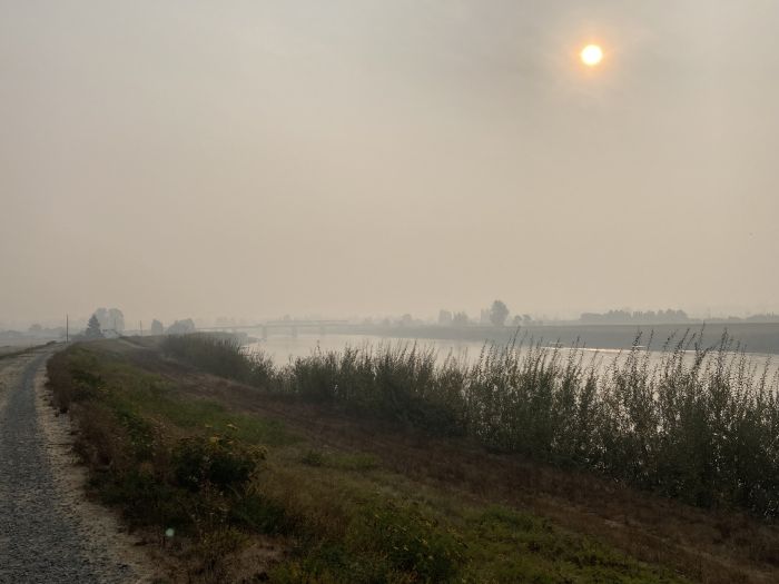
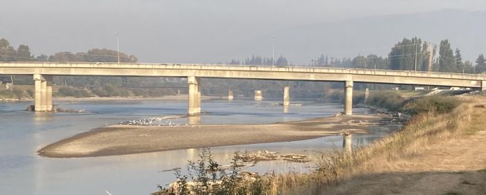
Well, there are those three little bridges, built over dry land, to connect the Fort Worth mainland to that imaginary island. Those three little bridges are waiting for a cement lined ditch to be installed under them, with Trinity River water diverted into the ditch, making the imaginary island.
The article Elsie Hotpepper directed me to was in the Fort Worth Report, titled City of Fort Worth prepares to kickstart Panther Island development — again.
Just the title to this article struck me as odd. The city is preparing to kickstart America's Biggest Boondoggle again?
I was not aware the development had stalled. The last it was much in the news was when Congresswoman's Kay Granger's son, J.D., was removed from the executive director job he was totally not qualified to do, whilst being grossly overpaid, and then hired by the Boondoggle, post firing, to be a Trinity River Vision Boondoggle consultant for $12K a month.
The only other news about the Boondoggle that I can recollect in recent years is those three pitiful little bridges finally being completed, after seven years, that, and Fort Worth got $400 million from the Democrat's infrastructure bill, which J.D.'s mother voted against.
It has long bugged me that, if, as touted, this is a vitally needed flood control and economic project, why has it limped along in slow motion, begging for a federal funding, rather than voting to pay for the vitally needed project themselves, like town's wearing their big city pants do?
And, need we repeat, this vitally needed flood control project is in an area which has not flooded in well over half a century, due to flood control levees already in place, which you in the more prosperous parts of America, already paid for. While other areas of Fort Worth, as in East Fort Worth, and other areas of Tarrant County, have real, serious, un-addressed deadly flood control issues.
Now, let's take a look at some of the gems of nonsense from this article about America's Biggest Boondoggle...
Oh yes, many towns in America would be envious to have an industrial wasteland adjacent to their downtown. And another one east of their downtown. Most big cities do not develop with such tracts of wasteland adjacent to their downtowns. Hardly anything to be envious of.
And, finally...
How can anyone who has been to an actual world-class tourist destination possibly think this imaginary island can ever possibly be such? Just look at that stunning skyline of beautiful downtown Fort Worth you see in the screen cap at the top. This is not a world-class town in any sense of the term....
I was not aware the development had stalled. The last it was much in the news was when Congresswoman's Kay Granger's son, J.D., was removed from the executive director job he was totally not qualified to do, whilst being grossly overpaid, and then hired by the Boondoggle, post firing, to be a Trinity River Vision Boondoggle consultant for $12K a month.
The only other news about the Boondoggle that I can recollect in recent years is those three pitiful little bridges finally being completed, after seven years, that, and Fort Worth got $400 million from the Democrat's infrastructure bill, which J.D.'s mother voted against.
It has long bugged me that, if, as touted, this is a vitally needed flood control and economic project, why has it limped along in slow motion, begging for a federal funding, rather than voting to pay for the vitally needed project themselves, like town's wearing their big city pants do?
And, need we repeat, this vitally needed flood control project is in an area which has not flooded in well over half a century, due to flood control levees already in place, which you in the more prosperous parts of America, already paid for. While other areas of Fort Worth, as in East Fort Worth, and other areas of Tarrant County, have real, serious, un-addressed deadly flood control issues.
Now, let's take a look at some of the gems of nonsense from this article about America's Biggest Boondoggle...
The Central City Flood Project could transform a partially blighted expanse of land just north of downtown into about 440 acres of prime real estate — also known as the Panther Island Project.
Could transform a blighted expanse of land? Could? After all this time, all this money, this project is stuck at could? And it is now known, simply, as the Panther Island Project? When did that happen? Whatever happened to the Trinity River Vision Authority, over which J.D. Granger was the Executive Director for years.
No mention is made in this article of the Trinity River Vision Authority.
Or J.D. Granger.
Or that J.D.'s mother voted against the funding that might finally give Fort Worth enough money to dig that cement lined ditch under those three bridges.
The project, which has experienced decades of delays, received over $400 million in federal funding this year, enough money to design and build two bypass channels. The corps recently projected the project will take eight to 10 years to complete.
Is there no investigative journalist in the Fort Worth vicinity who might want to look into why and how this project has experienced decades of delays? We are up to two bypass channels now? Taking another decade to complete? Yes, this seems very vitally needed.
And the nonsense continues...
The new strategic plan will be the second iteration of a plan for the Panther Island Project. The city and Tarrant Regional Water District initially developed its plan for the island, also known as the form-based code, in the early 2000s and revisited it in 2016 — all before the project received over $400 million from the federal government.
New strategic plan? Does anyone know what the old strategic plan was? The city and TRWD initially developed its plan for the island, known as form-based code? So, the new total name of America's Biggest Boondoggle is Trinity River Central City Uptown Panther Island District Form-Based Code Vision?
And then we have this doozy, including a Fort Worth staple...
A redevelopment project the size of Panther Island in the core of the city is unique, said Kenneth Barr, chair of the Real Estate Council. “Other cities would be very envious of us having the opportunity,” Barr said.
Oh yes, many towns in America would be envious to have an industrial wasteland adjacent to their downtown. And another one east of their downtown. Most big cities do not develop with such tracts of wasteland adjacent to their downtowns. Hardly anything to be envious of.
And, finally...
“My vision for Panther Island is that it’d be a world-class place for tourists to come and visit and see the best of Fort Worth, but also a place where our local residents can enjoy and feel like it’s for them as well,” Landeros said.
How can anyone who has been to an actual world-class tourist destination possibly think this imaginary island can ever possibly be such? Just look at that stunning skyline of beautiful downtown Fort Worth you see in the screen cap at the top. This is not a world-class town in any sense of the term....